Overview
The Umbro-Marchigiana project has been a labour of love, putting together some of my favourite haunts — both natural and man-made — rides and foodstuffs into an epic bikepacking jaunt whose centrepiece is a fabulous off-road climb of the legendary (for us at least) Monte Catria. This mountain, with its barren, bleak-looking twin summits, is visible from all over our northern corner of Umbria. On trips to the bar for coffee or morning runs along the valley, we notice when the snow bleaches it. I rode around it on the way to catch the ferry to Greece. We almost fell off it when we accidentally ended up straddling its massive limestone ridge — Il Corno del Catria, suitable for mountaineers in still, dry conditions — dressed in trainers and carrying a handbag and flask of tea, respectively.
I hope that it will become a contribution to more sustainable, car-free tourism, supporting small enterprises and, potentially, generating revenues for wildlife conservation in the protected areas the route passes through — these are very much the early stages of a work in progress.
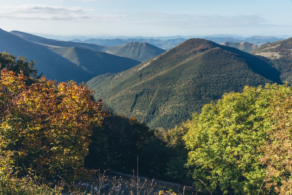
The 337km route (with optional 33km extension) meanders through Italy’s Apennine spine on a mixture of quiet paved (around 40%) roads, silky gravel strade bianche and more challenging rough stuff, climbing almost 10,000m in the process. The Umbria-Marche boundary is the watershed between Tyrrhenian and Adriatic slopes — part of the ‘Italy divide’. Beginning in the rolling terrain to the north of Umbria’s Lago Trasimeno, formed by tributaries of the Tiber (Tevere), it rollercoasters to Gubbio — arguably one of the country’s most underrated Medieval gems — leapfrogs the hills that tower over that city and climbs the shoulder of Monte Cucco, descending spectacularly on gravel to Scheggia, at the foot of the main Apennine ridge.
Crossing the divide into Le Marche, the Catria climb delivers stunning panoramic views west to Tuscany and east to the Adriatic Sea and plunges through the deciduous forest cloaking the northeastern slopes to the monastery of Fonte Avellana, still 700m above sea level. After dropping to the chocolate box hill town of Frontone, it snakes across rolling Marchese farmscapes, mainly on gravel hardpack, to the impressive Furlo Gorge. It ascends Monte Pietralata on the northern side of the gorge and tours the Riserva Naturale Statale Gola del Furlo on fantastic MTB tracks. To the north, Urbino, an independent Renaissance Duchy, gleams from its imposing hilltop seat. Riders can opt to visit this architectural pornfest via the extension loop, returning to the Furlo Nature Reserve and rejoining the main route on its journey to Cagli via some bucket list gravel grinding.

Above Cagli is the switchback climb of Monte Petrano, followed by a thrilling descent on service roads long ago turned to gravel and dust by frosts, rain and vehicle action. The trail meanders around in the shadow of the peaks of Petrano, Moria, Frontino and Nerone before briefly joining the provincial valley road (SP201 Pietralunga-Pianello) along the course of the Torrente Certano. Just after crossing back into Umbria, the route climbs again via gravel to above 800m, descending to the pretty hill town of Pietralunga at the head of the Valle del Carpina. The route rolls down this picturesque valley on an incredible gravel road (not track, road!) before climbing to Montone, another picturesque Medieval borgo with panoramic views.
Finally, after crossing the Tiber, we return to the Niccone Valley and straddle its watershed with the neighbouring Torrente Seano, repeatedly gaining and losing altitude on steep gravel tracks (switchbacks are wonderful things and missed in their absence), some turned rough by water movement and jeep tyres, before finally descending to Mercatale di Cortona in a brief excursion into Tuscany. The loop is completed by crossing the Torrente Niccone, which forms the Umbria-Tuscany border, to Lisciano.
Tracce GPX/GPX tracks (zip)
The basics
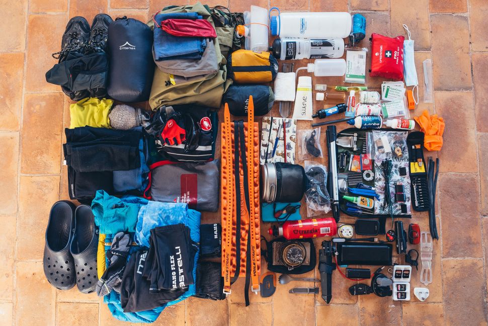
It’s rare not to be climbing or descending while riding the Umbro-Marchigiana. Some sections are steep and/or rough and will require ‘hike-a-bike’ for a loaded rig. However, these segments are fairly short. Ironically, the major mountain climbs tend to have the sting taken out of them by switchbacks. Nevertheless, a good level of fitness and confidence with loaded bike handing off-road will make the riding enjoyable rather than an ordeal to be endured. I scouted the route on a rigid bike with plush, knobbly MTB tyres. A hardtail would also work well. Personally, I’d consider that a gravel or ‘all road’ rig with relatively narrow tyres and road gearing would be underbiking the rougher stuff and detracting too much from progress and fun.

Food resupply opportunities are plentiful (and delightful). Piped water availability can be patchy outside settlements. Carrying a filter will broaden your scope to source from streams in addition to public fountains. The latter, in my experience, are perfectly safe to drink from. As in much of Europe, wild camping is officially illegal but may be tolerated or permitted with landowners’ consent. Commercial sites are marked on the map. I’m hoping to pilot smaller, informal community hosted pitches and facilities — watch this space. If you do wild camp, please avoid sensitive areas, such as the Monte Cucco Park and Furlo Gorge Nature Reserve, and strictly leave no trace. Take great care during hunting season (first Sunday of September to last day of February). That also holds for riding more generally — if you become aware of shooting activity nearby (at any time of year), make your presence known visually and audibly.


I love being in the Apennines during spring and autumn. Summers are very hot (and getting hotter) and busy, particularly in the July-August peak. It is also when cooler, shaded woodlands are inhabited by clouds of mosquitoes and tafani — small but voracious horseflies that draw blood with their painful bites. Snow can occur on the higher peaks at any time from autumn to spring but the skiing season runs from December to early March. In early spring and later autumn, when mist often hangs in valleys overnight, sometimes until late morning, multiple nights of bivvying in the damp cold is an unattractive prospect. You may choose to use a well-ventilated tent or take advantage of the variety of B&B lodgings on offer and lighten the load.

Although I’ve begun and ended the route near our home in the Niccone Valley, as a loop it can obviously be joined at any point. There are seven rail stations (marked on the map) on, or within riding distance of, the trail and bikes are readily carried on the Regionale and Regionale Veloce services that stop at them (subject to a bike supplement at €3.50 usable for 24 hours after validation). The lakeside village of Passignano sul Trasimeno (the starting point for the Umbria Trail, another fantastic bikepacking route) on the Foligno-Perugia-Florence line is over the hills from the Niccone Valley and would be a beautiful pre/post-tour ride of around 17km. From the eastern edge of Passignano, climb toward Castel Rigone on the SP142 to Trecine junction and descend into the Val di Rosa. Continue to Crocicchie and turn right up the climb to San Martino. Descend into the Niccone Valley. Alternatively, continue to climb past Crocicchie to the Cima del Protine and descend to Lisciano, or thread your way from Passignano to the Cima via tertiary roads and gravel using a good map.

You can access the Niccone Valley by alighting at Tuoro sul Trasimeno (stopping trains are infrequent here) or Terentola-Cortona (mainline services on the Rome to Florence line) and climb the Passo Gosparini above Tuoro, enjoying sumptuous views of the lake and surrounding hills followed by a thrilling descent (around 13 and 19km, respectively).
Another option is to join the route at Pierantonio or Montecastelli by using the Ciclopista del Tevere walking and cycling route. As the name suggests, it follows the Tiber river, linking Perugia with Cittá di Castello by a gravel/tarmac mix. Indeed, the Umbro-Marchigiana briefly follows it around Umbertide.

The great majority of the route is low commitment in the sense that on-road alternatives and short-cuts are readily available. The exception is mountain climbs, which are necessarily more remote and several are served only by unpaved tracks. Carrying the usual tools, spares, navigational back-ups and emergency equipment is a sensible precaution.
A late-season odyssey — the story of the scouting mission
Prologue — autumn in the Niccone Valley
For me, watching the prevailing weather moving through the valley from the terrace of our “village house” is better than anything Netflix can offer. When it’s accompanied by migrating Hirundines, as is often the case in autumn, it’s even better.


It’s very hard to train for cycling up mountains without cycling up mountains (notwithstanding the existence of turbo trainers, to some extent) and so various delays in setting off provided the opportunity to scout and ride local sections, getting some altitude gain into lowland England accustomed legs.


The grand départ
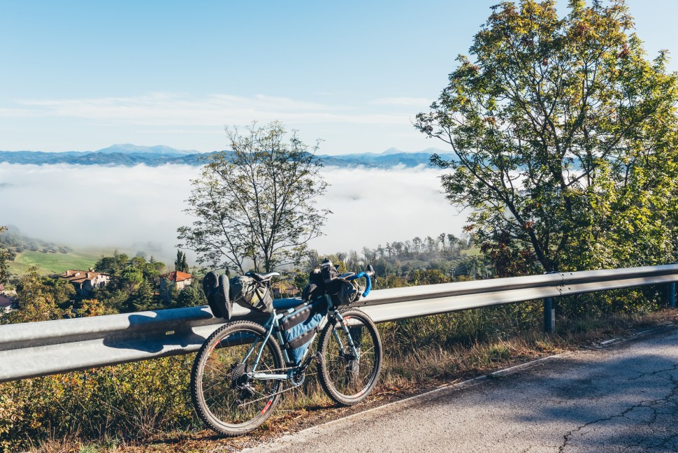
Departure day of the main scouting mission was one of those stunners that makes me so fond of the shoulder seasons in this part of the world. A still, cloudless night delivered a temperature inversion, with light frost in the valley bottom and thick cloak of sunken mist. Climbing above it, water dripping from the helmet visor, revealed warm sunshine, which lit thousands of spiders’ homes.


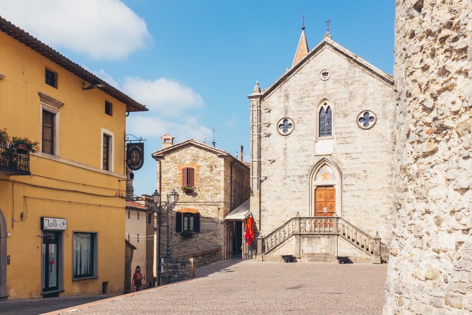
Gubbio
If Gubbio were in Tuscany, I contend that it would be world famous. The outrageous Palazzo dei Consoli is a 60m tall mini-skyscraper that actually helps to suspend the aptly, if unimaginatively, named Piazza Grande as a balcony over Umbria. The rest of the town is no less impressive a showcase of ancient engineering genius. If one gets bored with the Etruscan relics and Medieval marvels, there’s a Roman amphitheatre outside the walls. Then, there is the food and drink.


It is regionally renowned for its giant albero di Natale, formed in lights on the side of Monte Ingino. Less naff (sorry, I’m not a Christmas person) is its other celebrated annual tradition of the Festa dei Ceri, a “race” in which three competing 200-year-old giant wooden “candles” (the ceri), each topped by a saint, are theatrically borne up the mountainside to the Basilica di Sant’Ubaldo, named for the local patron, whose remains reside there. Appropriately, Sant’Ubaldo always wins.
The fascinating Museo Mestieri in Bicicletta (the museum of professions on a bicycle) should have particular appeal to bikepackers with its story of how loaded bikes helped Italian tradespeople rebuild their economic lives following the First and Second World Wars.


Gubbio to Scheggia

As in the rest of our flawed world, things in rural Central Italy don’t always happen as they should. It is not uncommon to find signage and barriers on public gravel roads that naughtily and erroneously suggest that access is limited. Some tracks, marked by blue strada privata notices are indeed privately maintained thoroughfares on land closed to the public. However, local residents may wrongly claim exclusive access to shared infrastructure and erect barriers with forbidding messages. In Italy, cycling is legally permitted on official footpaths (unlike in the UK, where this is the case only for public bridleways). The Club Alpino Italiano (CAI) marks trails with red and white symbols on trees, rocks and signposts, signifying that it’s legit for cycling.


The track system of the high ground between the summit of Monte Ingino and the plain from which the Apennine wall rises is devoid (as far as I could tell) of running water sources. By the time I crossed the valley, the sun was high and my bidon had been empty for a while. As I slowly ground my granny gear up the incline to Costacciaro, I passed a man supervising the repainting of his railings. I was travelling slowly enough to greet him and ask where the nearest tap was. He kindly replied that he’d gladly sort me out from his own. We chatted a bit, as I got my breath back and attempted to retain as much snot as possible within my COVID-19 compliant face mask (kept handy in my feed bag), and he asked, roughly translated, “What on Earth brings you to this place?” This bleak evaluation seemed a little unfair toward what was ostensibly a perfectly pleasant — if unexceptional — little borgo at the foot of the attractive and impressive Monte Cucco range and served as a reminder that we often fail to appreciate the familiar and well-known in the way an outsider might.


Scheggia, one of a chain of borghi to the west of the Apennine ridge, is small and unassuming but has a homely bar that was the perfect venue for writing up scouting notes with my staple caffé doppio and a pastry.
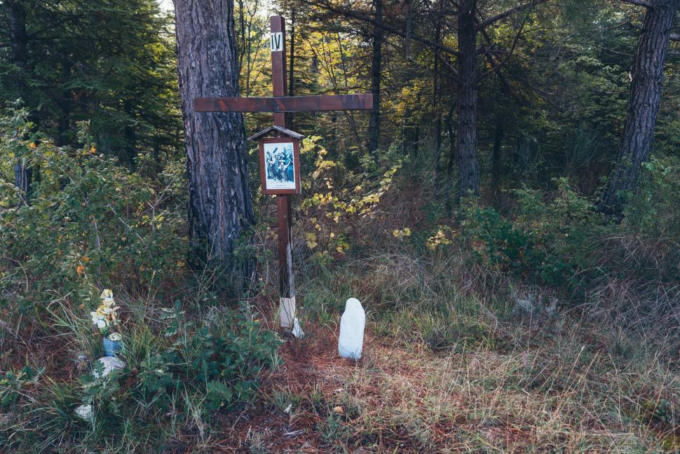
Crossing the border and the ‘Italy Divide’ — Monte Catria and Frontone
Le Marche — the Marches — region was named for the Medieval term march, or mark, meaning ‘frontier territory’. The Marca Firmana and Marca Anconitana had been merged by the 12th century and formed part of the Holy Roman Empire in the Kingdom of Italy after successive Popes wrangled with earlier incursions by the Normans. The mountains help the modern region to retain an atmosphere of remoteness and adventure, albeit now tamed by centuries of agricultural activity as the peaks yield to rolling hills. However, the region’s only flat land is in valley bottoms and the small coastal plain near Ancona.


Frontone to Furlo
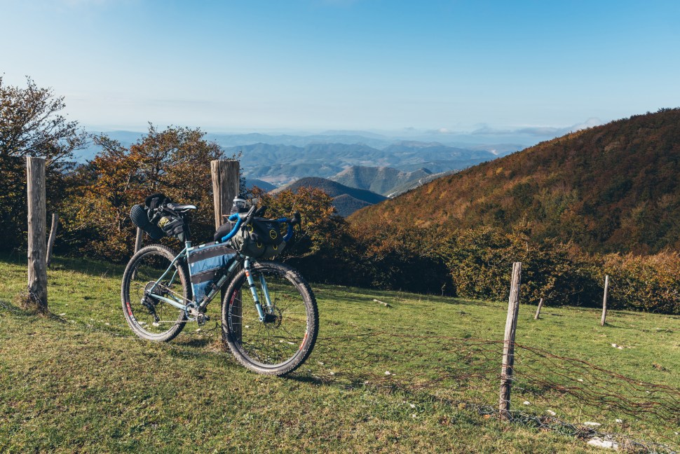
I’d initially allowed myself to imagine that it was, to a large extent, “job done” once beyond Catria’s formidable bulk, with the remainder of the route being relatively easy rolling. However, closer examination of the GPS track I’d split into three manageable chunks in order to ease the task of the Garmin’s processor revealed that altitude gain per kilometre was almost identical for the entire route. I couldn’t disagree with a sympathetic mountain biker who observed that, “These hills are hard!” as he overtook me on a steep strada bianca — the rolling topography is deceptive.


The Gola del Furlo — Furlo Gorge or Pass — is on the ancient Via Flaminia over the Apennines, linking the capital with Rimini. The Roman tunnel remained the only way through the pass until it was bypassed by twin highway bores in the 1980s. The Riserva Naturale Statale Gola del Furlo nature reserve extends beyond both sides of the gorge and has protected areas in five surrounding comuni. It is a gem of a place, criss-crossed on Monte Pietralata by great MTB tracks and home to locally and nationally scarce wildlife. The bird list includes golden eagle, peregrine, honey buzzard, hobby, Montagu’s harrier, kestrel, lesser kestrel, buzzard, blue rock thrush, crag martin, night heron, red-backed shrike, nightjar, corn bunting, Dartford warbler, woodlark, one of Marche’s few Alpine swift colonies, some of Italy’s (and Europe’s) most northerly breeding Lanner falcons, migrating dotterel and wintering wallcreepers and Alpine accentors.
Mammalian fauna includes wolves, beech marten, polecat, badger, dormouse, porcupine, water shrew, roe and fallow deer and an unknown collection of Chiroptera that is thought to comprise Leisler’s and European free-tailed bats, among others. There are also Italian tree frogs, Apennine frogs, Italian cave salamanders and the Po Valley goby, endemic to Northern and Central Italy.


Urbino extension loop
The optional northern loop to Urbino has a slightly greater proportion of paved surfaces than the main route but, if you like any of art, food, drink, architecture or history, I wouldn’t hesitate to include it. Oh, and the old town is a World Heritage Site. All of it. It is most famous for its independent Renaissance culture under the patronage of Federico di Montefeltro, the Duke of Urbino with a missing nasal bridge, immortalised in Piero della Francesca’s portrait.


Riserva Naturale Gola del Furlo to Cagli
This section is a treat for the discerning Gravelista. It is largely composed of smooth, wide gravel tracks linked by short sections of tarmac. I’m very fond of Cagli — once part of the Duchy of Urbino — itself. I remember drinking coffee and watching football in Caffé d’Italia, and gawping at the vast interior of the cathedral on a rainy afternoon when first exploring the region. It has its own Medieval Palio and hosts the delightfully niche artisanal (smoking) Pipe Festival. My one experience of dining there to date, at the Osteria Cucinoteca, was fantastic (a simple but delicious bowl of strascinati — a kind of orecchiette — with pistachio pesto, and a chocolate fondant with Amarena cherry were the highlights).


As I wheeled my rig past the Caffé del Teatro in search of some lunch, two patrons watched in fascination. Presently, they appeared where I’d paused to consult my phone for open eateries and one asked permission to inspect the bike. After looking around it in awe, he remarked to his friend, “It’s the future of cycling”. I love the reverence that so many Italians have for bicycles.

Cagli to Pietralunga
On a cold, bright autumn morning, the road to the altopiano at the summit of Monte Petrano was very quiet. Warmed by the climb and the sun, I donned a wind-cheating shell for the descent down the shaded western side, with temperatures still struggling to reach double figures. I stopped to chat with a very smiley, friendly elderly couple at the road junction to Pianello, who were confused that I’d mentioned I was heading that way but set off in the opposite direction. I explained, in my best bad Italian, that I was taking the long (off-road) way round.


Shortly before joining the Pianello-Pietralunga valley road, I stopped in the hamlet of Caimarini in search of water. This caused the local dogs to lose their minds, prompting their owners to emerge. This was helpful in not having to approach too closely as a sweaty, muddy apparition amid a global pandemic. The couple’s initial surprise and bemusement was replaced by warmth and quite some delight when they learned I was visiting from Lisciano Niccone and, ultimately, the UK. While filling my bottle from their outside tap I asked how things were here and how they were doing, still shouting over the baying hounds, and then wished them all the best. This is the kind of interaction I miss when reduced to signing and gestures in places where I don’t speak the language, however badly.


September-October is pilgrimage season and Pietralunga lays on the Cammino di Assisi, a long-distance trek based upon the wanderings of Frank, Umbria’s celebrity saint. It is at the heart of truffle country and on some of my favourite road bike routes from home. We stayed at a bed and breakfast here once when visiting the area while the house was being renovated, arriving into a party for winemakers from all over Italy, who were all keen that we sampled their products and the accompanying food (very much in that order).
Pietralunga to Montone

The strada bianca linking Pietralunga with Montone not only physically looks like a road but it is also marked on the MTB map as an orange line. Thus, I’d overlooked it, only realising my mistake while ankle deep in muddy puddles and enviously eyeing the line of pale gravel in the valley bottom from above.


Montone historically held power and influence that was hugely disproportionate in the context of the contemporary village of around 1,600 inhabitants. It was the stronghold of Andrea Fortebraccio, “Braccio da Montone” (1368-1424), who conquered most of Umbria, including Perugia, and was appointed Governor of Bologna. It is one of the region’s most attractive borghi with great bars and restaurants, and sweeping views over the Tiber and Carpina valleys.


The final leg — the Niccone Valley the hard way

I’ve enjoyed incredible luck with weather while bikepacking in Italy, and this scouting trip was no exception. The rainstorms that had been battering northern and central districts for weeks finally caught up with me on the northern ridge of the Niccone Valley. Although I was only around 12km from home as the local hooded crows fly, sticking to gravel means climbing and descending several times, skirting the village of San Leo Bastia in the neighbouring valley bottom before popping back over the watershed for the final time. Still, if you’re going to get a cold soaking, best to do it when your own hot shower beckons at the end of the ride.


Epilogue
The final day’s riding had reminded me of the “40% rule”, which I believe originates from US Navy SEALs and states that when your mind tells you you’re done, there’s actually another 60% in the tank. With cumulative tiredness in my body and having run out of Orsetti d’Oro (gummy bears) somewhere around Montecastelli, I felt I’d had enough with hundreds of metres of valley hopping still remaining. But seeing the house from my elevated perch on the opposite ridge immediately prompted a second wind and I stopped noticing the increasingly heavy drizzle and complaining stomach.

Having postponed this process for six months from the spring, anxiously monitored the constantly changing travel regulations, and dodged the appalling weather that was afflicting most of Europe to complete the route I’d envisioned with only minor alterations, I allowed myself a little air-punch when my muddy front tyre rolled to a stop against the foot of our stone steps.
I was just out of the shower when the doorbell rang fairly insistently. Grabbing a T-shirt and towel I emerged into what had become a steady downpour to be greeted by our wonderful neighbour Maria bearing handfuls of freshly-laid eggs. Bentornato indeed.

Very good.! Chapeau!
Is possible to have the GPX TRACK?
THANKS!!
Grazie, ti ho mandato un email.
Ciao Chris, complimenti il giro è bellissimo e anche le foto sono molto belle, complimenti! E’ possbile avere la traccia del percorso. ciao e grazie, Luca
I proposed up in those hills just about 30 years today. I must return. Please could you email me the GPX Chris.
Hi Bill, sounds like you also have good memories from the area. You can download the GPX files from the links above (below the maps).
All the best,
Chris
Thank you for such a wonderful piece of work
Thanks Mark, you’re welcome. Hope you get to ride and enjoy the route.